


NORTH ISLAND EDITION
Aotearoa New Zealand is a hiking heaven. Better known as tramping to the kiwis, exploring the outdoors by foot is one of the country's best attractions. Boasting a beautiful and diverse natural environment, you will find trails of all lengths, terrains and difficulties. It’s hard to narrow the list down to just a few favourites, but here are the 5 best day hikes we think you shouldn’t miss on the North Island.

QUICK LINKS
OMANAWANUI TRACK
The Omanawanui Track is quite simply an amazing trail with amazing views. Due to the Kauri dieback threats, the trail was closed for three years. During that time, the track underwent major upgrades before the highly anticipated reopening in 2021. Every step of the impeccably built trail offers unbeatable views across Manukau Harbour, Awhitu Peninsula and Whatipu Beach.


The Omanawanui Track is located on Whatipu Road in the Waitakere Ranges Regional Park.
There is a large car park at the end of Whatipu Road. The last few kilometres of this road are unsealed but well-maintained. There are also public toilets in the parking area. It is a short walk from the car park to the start of the track. Before starting the hike, you must use the wash stations to clean your shoes.
There is another smaller parking area that you will pass on Whatipu Road. This is the opposite end of the Omanawanui Track. If you start here, you will experience the same track, just in the opposite direction.
The hike takes around 2-3 hours to complete.
The new track is well-built, marked and maintained. There are a lot of stairs and a couple of rock scrambling sections with chains to assist. There is a seat at one of the lookouts and plenty of space to take a break along the way and enjoy the scenery.
TOKATOKA LOOKOUT
The view from the peak of this hike took our breath away. It wasn’t from the steep and muddy climb but rather the moment we stood at the top and realised it was worth every step to get there. At the Tokatoka Lookout, you are rewarded with spectacular 360-degree views across Dargaville and the Kaipara.

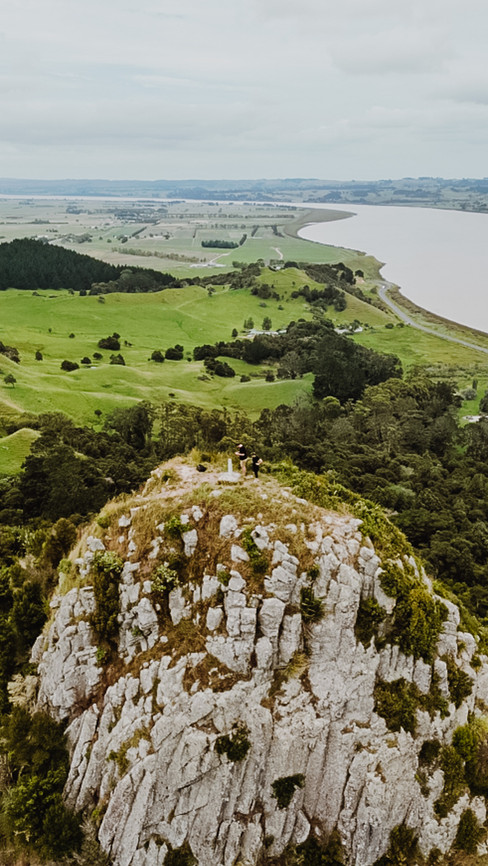


Tokatoka Lookout is located on Tokatoka Road in the Dargaville area of Northland.
There is a small parking section on the side of the road where the trail begins. Before starting the hike, you must use the wash station to clean your shoes.
The hike is approximately 700 m (2,296 ft) and takes around 25 minutes to complete, depending on track conditions.
This is a short but very steep track. The incline includes lots of stairs and rock scrambling. The path can get very muddy and slippery after wet weather. The flat area at the peak is small, with a sheer drop and no fencing or handrails.
TONGARIRO ALPINE CROSSING
The Tongariro Alpine Crossing is considered one of the best day hikes in New Zealand and one of the top 10 in the world. The hike offers spectacular views and picturesque lakes set amongst volcanic landscape. It’s easy to see why this hike is extremely popular among hikers and tourists, but it’s not a walk in the park. Being prepared before deciding to tackle the crossing is very important.


For more on this hike, check out our Tongariro Alpine Crossing ‘Know-Before-You-Go’ guide.
OMARU FALLS TRACK
One of the easier trails on this list is Omaru Falls. It is a short and leisurely walk that takes you across fields and through the forest to a small lookout point. At this lookout, you will find the waterfall at the end of the river you’ve been following. To say this waterfall is impressive is an absolute understatement. For such a quiet trail, the destination rivals some of the better-known tourist attractions in the area.


The Omaru Falls track is located on Omaru Road in the Piopio area of the Waikato region.
You can park on the side of the road where the track begins. Omaru Road is gravel but well-maintained and accessible by all vehicles.
The track is 1.7 km (1 mi) return and takes around 30 minutes one-way.
This is an easy trail, mostly flat and well-marked. It can get muddy after rain, and some sections may be slightly overgrown. There is a small swing bridge halfway along the hike and stairs to reach the lookout at the end.
EGMONT NATIONAL PARK
While the most famous images of Egmont National Park are of the picturesque Mount Taranaki, the dormant volcano is not the only attraction on offer. You may want to tackle the advanced Summit Track, but if you aren’t quite up to that, there is an extensive network of walking trails to choose from instead. Our personal favourite is the Stratford Plateau – Enchanted Forest – Waingongoro Track. Together, these three tracks create a loop that passes moss-covered tree trunks, trails under arching trees, hops across bridges and stepping stones through streams and provides stunning views of Mount Taranaki.


The hike starts and ends at the Dawson Falls Visitors Centre. The centre is at the end of Manaia Road, inside Egmont National Park. The national park is located in Taranaki.
There is plenty of parking at the visitors centre. There are also public toilets available and rangers on duty to assist with track information and planning. Many hikes depart from this location, so best to check the maps at the centre to ensure you follow the correct signs.
This particular trail is a loop track that takes 3-4 hours to complete.
The track to the Stratford Plateau is clearly marked and well-maintained. It is a steady incline to the plateau, including sections of stairs. You can return via this same route if you are looking for a shorter walk.
The Enchanted Forest track is easy to follow but overgrown in sections, can be quite muddy and includes a lot of uneven stairs. At the end of this track, you will cross a long swing bridge to the Waingongoro Track. If you are afraid of heights, this bridge may not be fun for you.
The Waingongoro track is easier than the last section but still requires a bit of a climb to return to the start.
NEW ZEALAND ITINERARY
For more on New Zealand, including accommodation, car rental, must-see places and more walking trails, check out our 2-Week North Island Road Trip guide.
OUR GOOGLE MAPS
When planning our travel destinations, we pin our bucket list of sites to see and recommended places to eat and drink on Google Maps. We are then never lost for ideas when travelling, and can easily share these lists for our friends and family to use too.
Click here to see our Google Maps for 5 Day Hikes in New Zealand (North).
Comments